
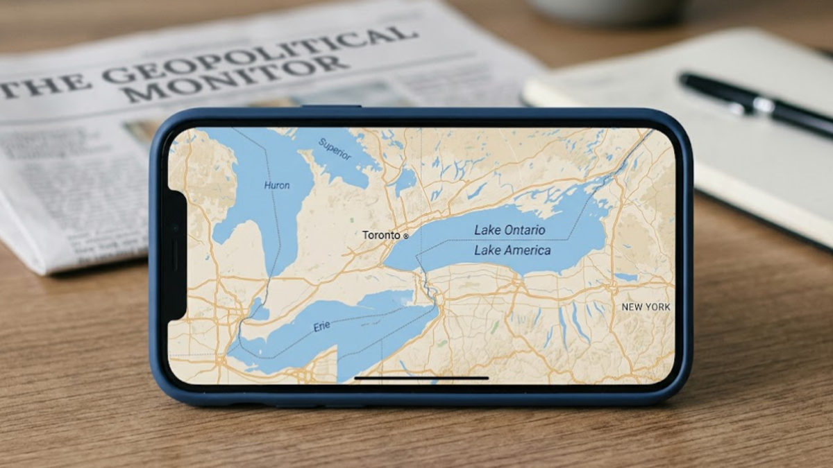
OTTAWA – Canadist: Lake America has appeared on Google Maps for users in the United States after Google updated its mapping service to reflect a U.S. government decision to rename Lake Ontario, while Canadian users continue to see the historic name Lake Ontario. Users outside the United States and Canada may see both names displayed together. But what does the split naming mean for Canadians, American users and the future of one of North America’s most recognizable lakes?

Google’s update follows an executive order from U.S. President Donald Trump directing a change to the lake’s name in U.S. government geographic records. The move has quickly become another point of friction between Washington and Ottawa, adding a symbolic dispute to already strained relations between the two countries.
For people opening Google Maps in the United States, the body of water that borders Ontario and New York is now labelled “Lake America.” In Canada, Google continues to identify the lake as “Lake Ontario.”
For users elsewhere in the world, Google says Maps can display both names, reflecting the different naming conventions used in the two countries.

The company says the decision follows its established practice of using official government geographic sources when determining place names. In this case, the relevant U.S. source is the Geographic Names Information System, or GNIS.
Lake America arrives on Google Maps after U.S. government name change
The change did not originate with Google. The company implemented it after the U.S. government formally changed the name in its geographic naming system.
Google explained that its Maps service follows official government sources for geographic names. Once the U.S. naming database adopted “Lake America,” Google began rolling the new label into Maps for people accessing the service from the United States.
That means the same physical lake can now carry different labels depending on where a person is viewing Google Maps.
A user in New York may see “Lake America.” A user in Toronto may see “Lake Ontario.” Someone viewing the same location from another country may encounter both names.
Google describes this approach as part of its long-standing policy for bodies of water whose names differ between countries. The company has used similar location-based naming practices for other geographic features where governments do not use the same terminology.
The distinction is important because the U.S. executive order does not automatically change Canadian naming conventions.
Canada has not adopted the new American designation. Canadian officials continue to refer to the body of water as Lake Ontario, and Google says Canadian users will continue to see that name.
The situation therefore creates a digital divide rather than a universally accepted geographic renaming.
The physical lake, of course, remains unchanged. Its shoreline, waters, islands, ports and international boundary remain exactly where they were before the dispute began.
What has changed is the label displayed by a major digital mapping platform.
Why Google Maps is showing different names
Google’s explanation centers on the source of geographic information used by Maps.
The company says it updates its mapping information to reflect official government sources. For the United States, that includes the U.S. Geographic Names Information System.
The U.S. government’s naming decision therefore triggered the Google Maps update for users located in the country.
Reuters reported that the executive order affects the U.S. geographic naming system and does not determine how Canada or the rest of the world refers to the lake.
This distinction matters because Google is not declaring that every country has accepted “Lake America” as the lake’s new international name.
Instead, the platform is presenting different names according to regional conventions.
Google has summarized the arrangement simply: U.S. users see “Lake America,” Canadian users see “Lake Ontario,” and users outside both countries can see both names.
For Canadians, that means the Google Maps experience remains familiar.
A person searching for the lake from Ontario will continue to encounter Lake Ontario. For Americans, however, the map now reflects the new U.S. designation.
For international users, Google’s combined presentation acknowledges the disagreement rather than selecting one name as universally authoritative.
That approach also illustrates how digital maps increasingly handle disputed or regionally different geographic names.
Instead of producing a single global label, mapping platforms can use a person’s location to determine which terminology appears on screen.
A name change with political consequences
The dispute over the lake’s name comes at a particularly sensitive moment in U.S.-Canada relations.
The renaming follows a period of escalating trade tensions between Washington and Ottawa, including reciprocal tariffs affecting billions of dollars in goods, according to Reuters and AP.
The timing has contributed to the political significance of the decision.
Canadian officials have rejected the American name change. Prime Minister Mark Carney dismissed the renaming, while Ontario Premier Doug Ford publicly reaffirmed the lake’s traditional name.
Ford responded by unveiling a large sign beside the lake declaring “Lake Ontario. Now and Always” in English and French.
The message was deliberately simple. It emphasized that the province does not recognize the American renaming as a replacement for the name used in Canada.
Ford also said the rest of the world would continue to call the body of water Lake Ontario.
The response illustrates the difference between changing a name in a country’s own government databases and achieving broader international acceptance.
A government can establish terminology for its own official purposes. That does not necessarily compel another government, private company or international organization to adopt the same terminology.
Google’s decision has therefore become significant precisely because Maps is used by millions of people for everyday navigation, business information, travel planning and geographic reference.
A label on a digital map can reach a much larger audience than an entry in a government database.
Canada continues to call it Lake Ontario
For Canadian users, Google’s position is clear: the map will continue to display Lake Ontario.
That is consistent with the position taken by Canadian political leaders and institutions following the U.S. announcement.
The name Lake Ontario has deep historical significance in the region. Canadian Prime Minister Mark Carney has pointed to its Indigenous origins, noting that the name predates the modern political boundaries of Canada and the United States.
The lake itself forms part of the international geography shared by Ontario and New York.
Its waters have long connected communities, transportation networks, industries and ecosystems on both sides of the border.
That shared geography makes the naming dispute unusual.
Unlike a landmark located entirely within one country’s territory, Lake Ontario sits within a broader international context. Its waters and surrounding communities are tied to both Canadian and American life.
The disagreement over the label therefore extends beyond a simple change to a database.
It touches questions about history, national identity, sovereignty and the role of governments in determining geographic terminology.
For Canadian users opening Google Maps, however, the immediate effect is straightforward: the name remains Lake Ontario.
Some Canadian websites have displayed “Lake America”
The Google Maps update has also created complications for Canadian websites that use Google’s mapping technology.
Ontario officials have acknowledged that some government and agency websites displayed “Lake America” after the mapping update.
Stephen Crawford, Ontario’s minister responsible for public and business service delivery and procurement, said the province was reviewing its websites after the new label appeared.
Some agency websites use Google Maps data directly, meaning that changes made by Google can appear automatically in third-party applications.
Reuters reported that “Lake America” appeared on websites including the Liquor Control Board of Ontario.
Canadian officials are now examining those instances to ensure that government-facing services identify the lake according to Canadian naming conventions.
This issue highlights an important technical consequence of the dispute.
A Canadian organization does not necessarily control every geographic label that appears on an embedded map. If its website relies on an external mapping provider, an update by that provider can change what visitors see without the organization intentionally changing its own terminology.
The problem can become particularly visible when the mapping service uses regional settings.
Google has said website developers who embed Maps can select a region for localization, which influences how geographic names appear.
That gives organizations some control, but it also means websites need to review their mapping configurations when politically sensitive geographic names change.
Lake America is not appearing everywhere
Google’s change does not mean every mapping platform has adopted the new American designation.
Reports indicate that other major map services have taken different approaches.
Apple Maps continued to display Lake Ontario for American users at the time of recent reporting, while MapQuest also declined to adopt the new name.
MapQuest publicly indicated that it would not change the lake’s name on its maps.
The different responses demonstrate that the U.S. government’s decision does not automatically force every private mapping company to make the same update.
Google has chosen to follow the U.S. government’s geographic naming database for its U.S. users.
Other companies can make their own decisions about which geographic authorities and naming standards they follow.
That creates another unusual feature of the dispute: people can potentially receive different names for the same lake depending not only on their location but also on the mapping service they use.
One person may open Google Maps in the United States and see Lake America. Another may open a competing mapping application and see Lake Ontario.
The physical geography remains identical, but the digital representation changes.
For travelers, businesses and international organizations, this can create confusion, particularly when people use different platforms to share directions, locations or geographic information.
The dispute follows the Gulf of Mexico controversy
The Lake Ontario dispute also echoes an earlier decision by the Trump administration involving the Gulf of Mexico.
After a previous executive order, Google Maps adopted “Gulf of America” for users in the United States while maintaining different terminology for users elsewhere.
The latest decision follows a similar pattern.
Google says its policy is to reflect official government geographic sources in the relevant market. When the U.S. government changes a geographic name, the company can update the U.S. version of its map while maintaining another name in countries that do not recognize the change.
The approach allows Google to accommodate competing national conventions without forcing every user around the world to see the same label.
That may reduce confusion in some situations, but it can also make digital maps part of political disputes.
A place name is no longer confined to printed atlases, government documents or physical signs.
It appears in search results, navigation applications, business listings, travel websites and mobile devices.
A change to a database can therefore become visible almost immediately to millions of users.
A digital map becomes part of the argument
The Lake America controversy shows how technology companies can become involved in political disputes without initiating them.
Google did not order the renaming. It responded to a change made in a U.S. government geographic database.
Yet once Google Maps adopted the new label, the company became part of the public debate.
For Canadians who continue to see Lake Ontario, the difference is particularly striking when compared with screenshots from the United States.
The two views show the same body of water but use different names.
International users can see both, making the disagreement explicit.
That creates a digital reflection of the political disagreement itself.
The development also raises broader questions about how mapping companies should handle geographic names when governments disagree.
Should a global map use one internationally recognized name?
Should it display each country’s official terminology?
Should disputed names appear side by side?
Or should users be allowed to select the naming convention they prefer?
Google has chosen a regional approach in this case.
Its policy allows the service to reflect the U.S. government’s terminology for U.S. users while preserving Canada’s terminology for Canadian users.
For users outside the two countries, displaying both names provides a compromise that acknowledges the competing labels.
What the Google Maps change means for Canadians
For most Canadians, the immediate impact is limited.
Google Maps continues to show Lake Ontario within Canada, so ordinary navigation and map searches should remain familiar.
The bigger impact is symbolic.
The name has become a visible point of disagreement between Canada and the United States at a time when the two countries are already dealing with trade tensions.
The controversy has also prompted Canadian officials to review government websites and digital services that depend on third-party map data.
Businesses that use embedded Google Maps may face similar questions.
If a website serves customers in both countries, its displayed geographic terminology could vary according to the visitor’s location or regional map settings.
That can matter for tourism, logistics, real estate, transportation and other industries that rely heavily on digital maps.
For international users, the situation may be even more straightforward: Google can display both names, allowing people to recognize the lake regardless of which national terminology they encounter.
The lake itself remains a shared geographic feature.
The disagreement exists primarily in the language used to identify it.
What happens next?
The immediate Google Maps update is already visible to U.S. users, while Canadian users continue to see Lake Ontario.
The bigger question is whether other mapping services will follow Google’s lead.
Apple Maps and MapQuest have taken different positions so far, demonstrating that there is no automatic requirement for private technology companies to use the same label.
The issue could also continue to affect Canadian government websites that rely on Google mapping data.
Ontario officials have already begun reviewing sites where the American name appeared unexpectedly.
For Google, the company has framed the decision as a matter of following official government sources and its existing policy for geographic names that differ across countries.
For Canada, the response has focused on preserving the name Lake Ontario.
For users around the world, the result is an unusual three-way map experience: “Lake America” in the United States, “Lake Ontario” in Canada, and both names in many other parts of the world.
That makes this more than a story about a single label.
It is also a story about how political decisions move into the digital services people use every day.
A government can change the terminology in its own records, but the international meaning of a place name depends on much more than one database.
And as Google Maps demonstrates, the same lake can now have different names on the same global platform depending on where the user is standing.
FAQ
Why does Google Maps show Lake America?
Google says it updated its U.S. maps after the U.S. Geographic Names Information System adopted “Lake America” as the U.S. name.
What do Canadian users see?
Canadian users continue to see the lake labelled “Lake Ontario” on Google Maps.
What do users outside Canada and the United States see?
Google says users outside the two countries may see both “Lake Ontario” and “Lake America.”
Did Canada officially rename Lake Ontario?
No. The U.S. naming decision does not change Canadian naming conventions, and Canadian users continue to use the name Lake Ontario.
Contact: info@canadaalyom.com